 |
| Gaylor Lakes Basin |
I’m doing some more back posing here. I had let my blog go into hibernation for a couple of months, but we did some really nice hikes during the week after Labor Day while we were camped out at
Tuolumne Meadows, so I thought they were worth writing up. A funny thing happens in Yosemite right after Labor Day. People start leaving in droves. The weather might actually be great, and the conditions may be superb, but most of the public packs it in and heads home right on schedule as the off-season officially begins. We were passing entire trains of cars and RVs going the other way as we were driving up highway 120 to Tioga Road. There are still services open at Tuolumne Meadows like the grill, store, mountaineering shop, and gas station, but overall, it’s much more peaceful.
 |
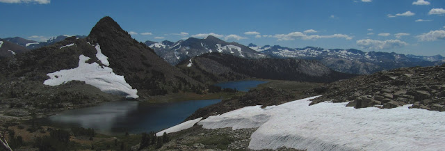
| Middle Gaylor Lake |
The winter of 2010 - 2011 had bumper crop snowfall, and even this late in the season, the upper Tuolumne is still flowing strong. The snow melt filtering down from the high Sierra crest is still actively feeding the myriad of lakes and creeks with fast moving
crystal clear water. If we only could get several years in a row like this one, we would begin to see the re-establishment of the Yosemite glaciers that have receded into extinction in recent years. All things considered, it was a great time to be in the high country. This trip was amazing because most of the hiking we did was on trails that neither one of us had ever been on before, which proved to be like a new awakening to the Tuolumne area. Some of the trails that I had bypassed on previous trips turned out to be really fantastic inspiring hikes.
Gaylor Lakes Basin was one of them.
 |
| Dana Meadows |
Being Santa Clara Valley
(anthill) dwellers who live at virtual sea level, we had planned this hike as an acclimation day because it seemed like the trail would not present a major challenge. We were interested in the trail that begins at the Tioga Pass entrance station to the park. There is a route to the lower Gaylor Lake that follows the Dana fork Tuolumne, crosses the river, crosses Tioga Road, and heads out across the moraine flat. That route is tempting, and would get you to the shores of the lower lake in about 5 or 6 miles. We decided on the other trail after one of the trail guides we read characterized that trail as “viewless”. So we used our car to get to the small parking area at the Tioga Pass trailhead, elevation about 9943 feet.
 |
| Leichtlin's Mariposa Lilly (Calochortus leichtlini) |
The trail begins by climbing about 600 feet up a small ridge system. The lower section is mostly populated with stunted lodgepole pines, but there is plenty under-growth and some wild flowers are still lingering. Among the most interesting were Leichtlin's Marisposa Lily
(Calochortus leichtlini), Pine Forest Larkspur
(Delphimium gracilentum), and some kind of yellow cinquefoil I still have not verified, and a few others. Climbing up the switchbacks you get a few glimpses of Mt Dana through the trees. The trail never gets very steep, even though I was feeling the altitude a little. This was only our first full day above 9000 feet. As you get close to the top the trees thin out to almost barren rock. Hiking along the side of the ridge, the openness provides the first view opportunity as you get unobstructed vistas down to the lush green Dana meadows, and a cluster of little ponds around the Tioga Pass area. You can see Mt Dana and Glacier Canyon, and lots of the Sierra Crest. After you crest the top, you can then see over into the Gaylor basin. The trees up here are mostly stunted white bark pine. The growing season is short up here.
 |
| Lemmon's Painbrush (Castilleja lemmonii) |
As you begin to descend into the basin, the middle Gaylor Lake, largest of the 3 Gaylor lakes, spreads out along a flat plateau with the wind buffeting the surface like an inland sea. In the background the still partially snow packed Sierra Crest stretches across the horizon in the distance. After walking along the middle lake, the trail then continues up a little eroded creek through lush grasslands dotted with wild flowers. We saw some brook trout in the creek, and assumedly they are in the lakes too. The trout are introduced. No fish can naturally spawn up this high because of all the waterfalls. There’s miniature lupine still popping up all around, and lots of Lemmon’s Paintbrush (Castilleja lemmonii), with it’s distinctive pinkish-purplish coloration. A few Sierra Wallflowers (Erysimum capitatum ssp. Perenne) are still around too. Sue really loves the fragrance of those. See my pictures for more species, some of which I still have not identified. Continuing up the trail following the creek, and gaining about 400 more feet, the upper lake comes into view. There was still some hard snow pack along the trail and we walked over that rather than sink into the marshy soil along its edge, which almost had the consistency of quicksand. The lake is surrounded by barren rock slopes with Gaylor Peak right across reflecting in the clear waters. The trail begins to climb again, headed up into the rocks to a plateau at 10,780 feet where the remnants of a long abandoned silver mine lies, called the Great Sierra Mine. The views from this place are simply superb. An intricate variety of peaks, some green, some barren, some still with packed in snow, and stunning clear lakes with melt water flowing down the course of the creeks. You can walk around and see the various ruins of the old mining camp including an old filled in mine shaft. You can also walk over to a little rock ledge for a fantastic view down Lee Vining Canyon and enjoy a great view of Mt Conness, the highest peak in Yosemite. It’s a short hike of only about 8 miles round trip, but is worth spending some time here enjoying the quietness and stark beauty. More energetic hikers can walk cross-country to over to Granite Lakes, or explore off trail further back in to the rocky terrain beyond the mine site. I didn’t record a track log, but I do have a photoset on flickr.


No comments:
Post a Comment