 |
| Echo Creek |
Whenever I make a return visit to a location as high on my list of favorite-places-on-earth as Yosemite, the sensory experience of being there has the effect of stimulating a host of old memories of really great camping and hiking trips from years past. When planning a day’s hiking, it can be hard to decide whether to use a route that you know already from a past hike that was especially rewarding somehow, or to seek out new experiences by looking for the best of what you may have missed on previous visits. We have a whole collection of maps and books that we’ve collected over the years. Perusing them all can actually be a little daunting. But on this trip Sue stumbled across a trail description from a little old dog-eared book from who knows when. The book is from a series called High Sierra Hiking Guides by Wilderness Press, copyrighted 1970. These little books do not include any maps. They’re really only collections of trail descriptions, with basic directions on how to get to trail heads, and some marginally useful photos. I do have some nice National Geographic topo maps but they can only show you so much. Reading from the guide book for the Tuolumne Meadows area, there is a fairly detailed description of a route called the “Vogelsang Loop”. The route is a 28+ mile high country loop that is better undertaken as a backpacking trip. Surely this is not the kind of terrain to march over like you were trying to set some kind of record. We’re really just looking to have a nice time in the mountains while recharging the proverbial batteries. But we noticed something interesting. Another of the hike descriptions focuses on a portion of the same loop as an out-n-back to a place called Nelson Lake. The hike begins from the
Elizabeth Lake trailhead, which begins at the same campground we were at. However, checking all of our maps, they all show the trail ending in the vicinity of Elizabeth Lake. Searching beyond to the south, Nelson Lake is shown as a feature, but with no trail leading there. Even still, the area seemed very inviting, secluded, and surrounded by unique terrain features, capturing our interest. Obviously there was a trail there at one time, so after considering all the options and making absolutely sure to put fresh batteries in the GPS just in case, we decided to use that tattered old trail description to lead us to this place called Nelson Lake. We were well prepared, but I was expecting this hike to be a lot of fun no matter what happened.
 |
| Elizabeth Lake and Unicorn Peak |
The hike up to Elizabeth Lake in the morning air was refreshing. Trailhead elevation is about 8600 feet. There are still some wild flowers sprinkled around as you hike up through the woods. In many areas there is brilliant green ground cover which at casual glance looks like grasses. But a closer look and you discover that this is actually a leafy succulent of some kind. Unicorn Creek is not far off, and you can hear the gentle sounds of its course. These woods are beautiful, and if you are early enough, there are no people around. When you reach Elizabeth Lake at 9500 feet you are greeted by commanding views of barren and alien looking Unicorn Peak to the west, and Johnson Peak to the east looking more like a huge knarly rock dome in the middle of a forest. The lake is surrounded by woods and shrubbery, and has rocks strewn about as though fallen from the sky. Signs of ancient glacial activity are everywhere up here. A trail leads around the shores, buy we didn’t take time for that. Elizabeth Lake is pretty, but we knew more people would be along soon as this place is a popular short day hike by itself. We were much more interested to head on up the rocky pass toward Nelson Lake.
 |
| Cloudy view from the pass |
We quickly found the trail heading south across the lovely open green meadows shadowing the sandy banks of a meandering stream enjoying the breezes. The trail is not marked, but is easily discernable. After about a mile the trail starts climbing again and the habitat changes back into dense woods with many tall, fragrant, incense cedar. The grade keeps getting steeper and soon you are confronted with a steep slope that resembles more of a rock talus, except that the rocks are more embedded in the soil rather than being loose. It’s almost like a natural staircase. What had been a very discernable trail had now become much more obscure. There were no cairns or trail markings at all, making dead reckoning a more reliable way to find you’re way up to the pass at the top of the ridge. I might have built some cairns if I had been sure we were on the best route. We kept hiking up using rocks as steps, and along a passable slot between two steep slopes, and eventually found the trail again on the other side. But pausing at the top of the pass at 10,206 feet the views open up to a breathtaking panorama to the north over the treetops, across Tuolumne Meadows dotted with rocky outcrops, to an expanse of high mountains across the horizon. We took a break at the summit to enjoy the sights before heading on. Views like that are not to be wasted by being in too much of a hurry. Proper trail etiquette compels you to stop, relax, and drink it all in. After all, this is why you hike the Sierra.
 |
| Zoomed view to Vogelsang Peak |
Back into the trees again the trail begins leading downhill, switching back and forth down through a rocky canyon. You can hear water flowing in a stream down below that is concealed by thick vegetation. As you look through the sparse trees to the west, you can spot the jagged crest of the Cockscomb looming above, and soon the entire Mathis Crest dominates your view to the west as you descend into a valley bordered by the Mathis Crest to the west and Rafferty Peak to the east. As the trail levels out near the bottom, the valley opens up into green meadows, strewn with rock, and a stream system meandering along its course, and lots of wild flowers. In the distance to the south commanding attention in your forward view is Vogelsang Peak directly in your path, which gives you a great landmark for keeping your bearing. As we continued heading south a few more miles, we could notice the trail becoming more obscure, so we began relying more on the GPS than the map or trail. I have California Topo loaded in my GPS, and the mapping is detailed enough to show all the terrain features and Nelson Lake, so we knew we were close. As we approached a solid rock slope, the trail had completely vanished into obscurity, and we were not sure if we should head straight for the lake over the rocks, or continue to follow the stream which would maybe lead around them. We decided to hike up the rock slope to gain higher ground for sight reckoning, which was the more direct route anyway. We hiked over a long rock formation and down into a wooded valley again, and then up another rock slope. Reaching a little pass at the top of the rock ledge, I looked over into the sheltered valley where Nelson Lake lies, ringed by trees and grasses, and surrounded by high jagged peaks and flowing layers rock. Not a sole was down there, and there were really no signs of any human influence at all. It seemed almost perfect. A veritable Shangri-la. This would be a fantastic place to camp out for the night, and permits for the area are available.
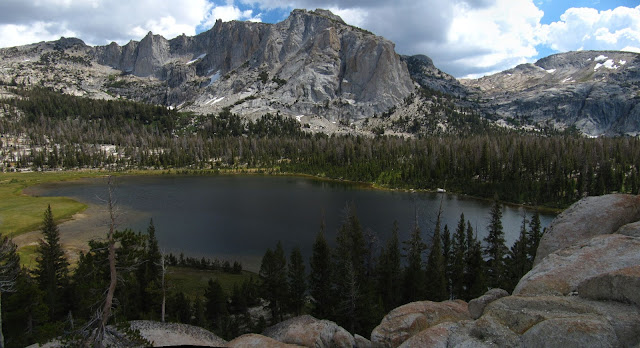 |
| Nelson Lake |
As we were leaving, we followed our track log back to the trail without doing much exploring. I’m still not sure if the old trail follows the stream around the rocks, or if you need to climb the rocks to get down to the lake. I suspect I’ll be coming back here sometime, so maybe I will have more time to investigate then. We wanted to head back because the skies were beginning to look stormy as the afternoon wore on. The sky in fact continued to darken, and we got rained on a little bit off and on, but not enough to really get soaked. I took some more pictures when we reached the summit pass near the Cockscomb to show the difference in the sky from in the morning. I had been a little concerned about having to hike back down the steep rock slope, slick and wet, down to the lower trail again, but it was no problem. It didn’t get that wet. We did not see any other people until we were back at Elizabeth Lake. We had been on a fabulous hike, and true to the words of John Muir, our cares had melted away.
Click here to see the track log at EveryTrail
Click here to see the photos on flickr


2 comments:
Another great adventure Randy. I want to get back out to the high country and you are definitely whetting my appetite.
Thanks Dave. Almost time to make next years reservations.
Post a Comment